logo2

ugm-logo

Sebagian Besar Wilayah NTB Tergolong Rentan Bencana

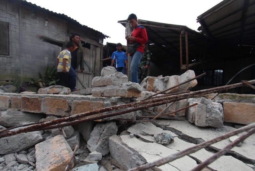
Ilustrasi.

REPUBLIKA.CO.ID, MATARAM -- Wakil Gubernur Nusa Tenggara Barat (NTB) Muhammad Amin mengatakan sebagian besar wilayah NTB tergolong rentan bencana.

"Dari 14 jenis potensi bencana di Indonesia, 11 di antaranya terdapat di wilayah NTB. Penyebabnya kondisi geologis NTB terutama di wilayah pegunungan dan pesisir pantai, mulai dari barat sampai timur rawan bencana," ujar Amin saat membuka rapat koordinasi peningkatan kapasitas pemerintah dan masyarakat dalam penanganan bencana di Hotel Lombok Raya, Mataram, NTB, Selasa (8/8).

Amin menyampaikan mengantipasi kerentanan bencana tersebut, tidak hanya membutuhkan program penanganan secara komprehensif dan terintegrasi, tetapi juga menyiapkan masyarakat agar tangguh bencana.

Menurut Amin, kejadian bencana sudah pasti akan menurunkan bahkan melumpuhkan tingkat produktivitas masyarakat. "Misalnya, tidak sedikit lahan yang tadinya bisa ditanami ketika datang bencana banjir akan rusak, dan juga infrastrukturnya rusak," ucap Amin.

Merujuk pada Undang-Undang Nomor 24 Tahun 2007 tentang penanggulangan bencana, Amin mengingatkan, penyelenggaraan penanggulangan bencana merupakan tanggung jawab pemerintah pusat dan pemerintah Daerah.

Pria kelahiran Sumbawa, NTB, berharap dalam menjalankan amanah konstitusi tersebut, perlu disusun suatu konsep penangulangan bencana yang terencana, terkoordinasi dan menyeluruh, mulai dari tahap pra-bencana, saat tanggap darurat, dan pasca bencana.

Amin meminta pemerintah daerah dan semua pihak terkait untuk menyatukan langkah-langkah taktis yang cepat dan tepat untuk meminimalisir dampak bencana sekaligus mempersiapkan diri untuk menghadapi resiko bencana di masa depan.

"Sebagai langkah preventif, saya meminta BPBD NTB selaku leading sector penanggulangan bencana lebih mengintensifkan sosialisasi kepada masyarakat agar menjadi masyarakat tangguh bencana," kata Amin.

Asisten Seputi Tanggap Cepat Bencana Kementerian Koordinator Pemberdayaan Manusia dan Kebudayaan (Kemenko PMK) Joko Yuwono berharap hasil rakor ini memperoleh masukan-masukan dan pemikiran serta komitmen lebih jauh lagi agar dapat mengantisipasi berbagai permasalahan kebencanaan.

"Untuk selanjutnya dapat dirumuskan berbagai langkah upaya penanggulangan melalui keterpaduan kebijakan dan perencanaan khususnya dalam pengurangan resiko bencana," ucap Joko.

Asisten Deputi Pengurangan Resiko Bencana Kemenko PMK Herbin Manihuruk mengatakan berdasarkan hasil indeks resiko bencana 2014, dari 478 kabupaten/kota, 77 persen wilayah Indonesia merupakan risiko tinggi rawan bencana. Untuk NTB, lanjut Herbin, 88 persen wilayah di NTB menjadi lokasi prioritas.

Herbin melanjutkan, dalam mengantisipasi terjadinya bencana perlu ada sinkronisasi antara pemerintah pusat dan daerah. Herbin juga mengungkapkan gagasannya tentang upaya mewujudkan ketangguhan bencana di setiap desa. Artinya, ketika terjadi bencana, pihak pertama yang bisa menyelamatkan masyarakat, bukan BPBD atau Tim SAR tetapi masyarakat itu sendiri.

"25 persen bisa selamat karena diri sendiri, maka dari itu masyarakat harus kita internalisasikan bagaimana upaya-upaya penyelamatan diri. Jadi program pembentukan Desa Tangguh Bencana menjadi prioritas yang perlu kita sukseskan bersama," ungkap Herbin.

Nepal Fatcsheet: Community-Based Disaster Risk Management (CBDRM)

This project aims to strengthen local capacity for emergency preparedness through a Community-Based Disaster Risk Management (CBDRM) approach and to increase the resilience of livelihoods through the prevention of landslide disasters and establishment of safer agricultural livelihood strategies. Prevention of landslide disasters in the targeted watershed areas reduces the loss of life and livelihoods related to such hazards.

The Gorkha Earthquake of April 25, 2015 in Nepal triggered thousands of landslides, affecting the lives and livelihoods of communities in rural areas where landslides are already frequent and serious hazards. The devastating earthquake not only impacted land productivity due to loss of mountain landmass and topsoil, but also affected settlements, resulting in loss of lives, properties and assets. Agriculture is the main source of food security, livelihood, and employment in the rural areas which are badly affected by natural calamities, such as earthquakes and landslides. As such, Nuwakot is one of six severely earthquake affected districts where risks due to landslides and erosion have increased and exacerbated the vulnerability of rural, agriculture-dependent farmers.

Consequently, the Department of Soil Conservation and Watershed Management (DSCWM) under the Government of Nepal (GoN) Ministry of Forests and Soil Conservation (MoFSC) has initiated an effort to harmonize landslide inventory methods and standardize landslide hazard, vulnerability, and risk-mapping methodologies. In response to these concerns, the UN Food and Agriculture Organization (FAO)—with support from USAID’s Office of U.S. Foreign Disaster Assistance (USAID/OFDA) is providing technical assistance to the DSCWM, supporting slope stabilization and landslide mitigation with proven technologies and experience. The project is a pilot initiative, demonstrating appropriate landslide treatment and mitigation techniques using the bi-engineering approach to reduce crisis in watershed areas.

PROJECT OVERVIEW

The MoFSC and the Ministry of Finance (MoF) have endorsed the project working modalities in December 2016. The DSCWM has formed a Project Steering Committee (PSC) with Focal Person for this program at the national level. The District Soil Conservation Office (DSCO) has nominated Focal Person as instructed by the DSCWM at local levels. The project team, along with Focal Persons, visited and finalized the priority sites for landslide treatment and mitigation together with livelihood support activities through Focused Group Discussion (FGD) among the direct beneficiaries.

PROJECT ACTIVITIES

  1. Received endorsement of the project from the MoF and MoFSC with the nomination of Focal Persons at national and district levels. The GoN focal persons, together with the FAO team, had a joint visit to the project sites and finalized a list of critical landslide areas for immediate treatment and mitigation, as well as several livelihood support activities.

  2. Selected a local NGO Service Provider based on a competitive basis in line with FAO Standard Procurement Guidelines.

  3. Provided training on nursery management and expects to produce 50,000 saplings of different species suitable for soil conservation and fodder trees.

  4. Developed user-friendly Agricultural Hazard and Vulnerability Mapping (AHVM) Tool Kit and short video as base line information.

  5. Mobilized the Community Forest User Groups (CFUG) in all three Village Development Committees (VDCs) and formed sub-groups within the CFUG for implementation of project activities.

  6. Completed the detailed survey, estimates, and designs in all three critical landslide areas for treatment and mitigation works.

7. Other regular ongoing activities include:

  • Support for landslide treatment and mitigation using suitable bio-engineering approach

  • Support local agriculture-based livelihood activities identified during the Focus Group Discussion

  • Regular nursery management and community plantation (CFUG)

  • Regular coordination among the government agencies, communities, and other relevant stakeholders working in landslide treatment and mitigation

  • Capacity building of beneficiaries and government officials on the bio-engineering approach in landslide treatment and mitigation and Early Warning System (training, exposure visits, and orientation etc.)

  • Develop community level “Watershed Management Plan” (Darkhukhola sub-watershed Level) Develop the Early Warning Systems at local level

  • Regular reporting and documentation of lessons learned and success stories

RESULTS ACHIEVED

The expected result of the project is to support earthquake-affected communities of 3 VDCs in Nuwakot’s Darkhukhola sub-watershed with appropriate technologies on landslide treatment and mitigation, and bolster safer livelihood activities to reduce loss of life and livelihoods due to landslide-related hazards.

More Articles ...